Homeschoolers and classroom teachers can build geography basics with engaging, child-friendly US maps. This guide highlights top physical maps designed for kids, balancing color, clarity, durability, and hands-on learning. Each product below supports visual learning, memory retention, and early geography skills. Explore options from wall maps to interactive puzzles to find the best fit for your child or classroom.
| Product | Brand | Format | Highlights |
|---|---|---|---|
| Lighthouse Geographics USA Wall Map for Kids | Lighthouse Geographics | 18” x 29” Laminated Wall Map | Durable, detailed with state borders, parks, rivers, landmarks |
| Momo & Nashi USA & World Map 2pc Set | Momo & Nashi | 24” x 16” Posters | Bright, engaging visuals; easy labeling for early learners |
| Uncle WU United State Map Laminated Poster | UNCLE WU | 17 x 23 inch Laminated Poster | Double-sided, waterproof; ideal for home and classroom decor |
| The Learning Journey Lift & Learn USA Map Puzzle | The Learning Journey | 40-piece puzzle | Raised textures; develops fine motor, memory, and problem solving |
| Mr. Pen United States Map for Kids | Mr. Pen | 14.5” x 24.6” | Vibrant colors; clear fonts and icons for quick recall |
USA Wall Map for Kids With Illustrations

Brand: Lighthouse Geographics. This laminated wall map is designed for long-term use in homes and classrooms. It emphasizes vibrant colors and detailed illustrations that highlight state borders, national parks, major cities, and rivers. The artwork adds an engaging layer to geography lessons while keeping the map durable for daily handling. Its versatile design makes it suitable for decor, seating charts, or trip planning activities, offering a practical resource for teaching children about the United States.
World Map Poster & United States Map for Kids 2pc Set
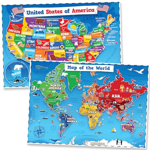
Brand: Momo & Nashi. This 2-piece set includes a USA map and a world map, designed for early learners. The posters use bright colors and artist-drawn icons to spark curiosity about continents, countries, and U.S. states. They are especially well-suited for preschool classrooms, playrooms, or homeschool spaces, helping kids build geography vocabulary and visual recognition without overwhelming detail.
United State Map Laminated Poster

Brand: UNCLE WU. A laminated, double-sided poster that’s waterproof and easy to wipe clean. It’s designed for classrooms and homes, offering a sturdy option for interactive lessons, travel planning, and decor. The laminated format ensures durability in high-traffic spaces and with young learners who may handle materials less carefully.
Lift & Learn USA Map Puzzle

Brand: The Learning Journey. This 40-piece puzzle features raised, brightly colored states that help kids place each piece accurately. The interactive format supports research, tactile development, and critical thinking. Its compact size makes it suitable for desks, tables, or travel activities, promoting independent play and a sense of achievement as children complete the map.
Mr. Pen United States Map for Kids

Brand: Mr. Pen. A kid-friendly map featuring vibrant colors, clear fonts, and labeled states. It’s designed for young learners to quickly memorize locations and landmarks. The map supports early geography lessons, mapping skills, and curiosity without overwhelming detail, making it a practical classroom or home resource for children just starting to explore the United States.
Buying Guide
- Age and learning level: Choose maps with age-appropriate detail. Early learners benefit from bold labels and simple icons, while older kids can handle more geographic details such as national parks and major rivers.
- Durability and format: Laminated or dry-erase surfaces offer longevity in high-traffic areas. Wall-mounted maps save space, while puzzles provide hands-on practice and fine motor development.
- Visual clarity: Look for high-contrast colors, legible fonts, and clearly defined state borders. Avoid maps with overcrowded labels that can overwhelm young students.
- Interactivity: Puzzles and dry-erase boards encourage active learning and repetition. Consider your teaching style and whether you prefer a static reference or an interactive activity.
- Educational content: Maps with landmarks, capitals, and parks can boost cultural and regional awareness. Some sets pair the USA map with a world map to broaden geographic context.
- Maintenance: Laminated and wipe-clean options simplify cleanup after activities. Consider how often you’ll update or replace materials as children grow.
- Space and room aesthetics: If you have a small classroom or kids’ room, select a compact design or a set that can be mounted without dominating the wall space.
How to Choose For Your Child Or Classroom
For beginners, a large laminated USA map with bright, distinct labeling provides a solid reference and reduces frustration. For hands-on learners, a lift-and-learn puzzle or a dry-erase map encourages exploration and repeated practice. If you want to introduce global context, a 2-poster set with a world map complements the US-focused map well, supporting cross-continental comparisons and cultural awareness. Consider pairing any map with interactive activities like tracing capitals, locating rivers, or identifying national parks to reinforce retention.
Usage Scenarios
In a home setting, hang a large wall map in a common area for easy reference during storytelling or travel planning. In classrooms, use the laminated maps for group activities and the puzzle for individual skill-building stations. For adaptive learning, rotate between a static map and an interactive activity to address different learning styles and keep geography engaging.
Selected products emphasize durability, educational content, and kid-friendly design. The Lighthouse Geographics wall map and UNCLE WU laminated poster provide stable references, while the Momo & Nashi 2-piece set adds engaging world context. The Learning Journey puzzle offers hands-on learning, and Mr. Pen’s map combines clarity with vibrant visuals for everyday study.