Learning geography becomes an adventure with interactive and visually compelling maps designed for curious young minds. This guide highlights top kid-friendly map sets that blend colorful art, durable construction, and informative features. Explore options that help children recognize countries, capitals, oceans, and landmark trivia—whether at home, in classrooms, or on the wall. The picks below emphasize educational value, durability, and engaging formats suitable for ages 5 and up, across wall posters, interactive talking maps, and playful learning games.
Summary of featured products
| Product | |||
|---|---|---|---|
| BEST LEARNING i-Poster My World | Interactive Talking World Map | Over 500 voice-guided questions; learns countries, flags, and facts | BEST LEARNING |
| BEST LEARNING i-Poster My USA | Interactive Talking United States Map | States, capitals, and facts via spoken guidance | BEST LEARNING |
| World & USA Map 2 Pack | 2 Laminated Posters | Durable learning posters for continents, countries, and U.S. states | Palace Learning |
| Rand McNally Kids’ Illustrated World Map | Printed World Map | Color-coded continents with illustrations and labeled references | Rand McNally |
| USA and World Map 2 Pack | Laminated Posters | Clear labeling of capitals, oceans, and continents | Young N Refined |
BEST LEARNING i-Poster My World
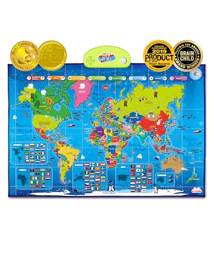
The BEST LEARNING i-Poster My World is an interactive learning tool designed for children ages 5 to 12. Tapping any country triggers voice-guided information, including the country name, capital, and more than 500 questions. This format fosters memory through auditory reinforcement and hands-on exploration. The map covers continents, oceans, landmarks, and flags, expanding children’s awareness of global diversity while strengthening geographic literacy.
Key features emphasize engagement and STEM-inspired curiosity. The device is recognized with family-friendly awards, underscoring its appeal to both boys and girls. By combining play with geography, the i-Poster supports independent exploration and guided play, making it suitable for classrooms and homeschool settings alike.
Ideal for: early geography learners, interactive storytelling, and family study sessions where kids benefit from hearing facts read aloud as they navigate the map.
BEST LEARNING i-Poster My USA

The BEST LEARNING i-Poster My USA focuses on United States geography. Children can tap any state to hear its name, capital, and more than 500 spoken facts. The interactive format supports memory-based learning and contextual understanding of regional differences across the country. It’s suitable as wall decor that doubles as an active study tool or a floor mat for interactive, mobile play.
Award recognition signals trusted educational value, with accolades from Family Choice and Brain Child. The dual-function design supports both quiet, reflective study and lively group activities. Its versatility makes it a strong fit for homeschool rooms and classroom corners where visual and auditory learners thrive.
World & USA Map 2 Pack

Palace Learning offers a practical 2 poster set featuring a world map and a USA map. Each poster measures 18″ by 29″ and includes high-quality lamination for durability in busy classrooms and homes. These maps are designed for early geography learning, helping kids connect continents with countries and major landmarks. The laminated surface makes them easy to clean and reuse in various settings—from playrooms to libraries.
The emphasis is on visual learning and memory retention. Bright, clear labeling supports recognition of continents, oceans, capitals, and country locations. The two-poster format is ideal for comparing global layouts with the U.S. map, enabling integrated lessons on geography, civics, and global awareness.
Rand McNally Kids’ Illustrated World Map

Rand McNally’s illustrated world map features color-coded continents with engaging illustrations of plants, animals, landmarks, and cultural icons. Capitals and major cities are labeled, along with bodies of water, providing multiple points of reference. Printed on sturdy paper, this map is durable enough for classroom use and kid-friendly enough for bedroom walls. It serves as a visual anchor for geography lessons, sparking curiosity about different regions and the people who live there.
USA and World Map 2 Pack

This 2-pack from Young N Refined includes laminated USA and World maps, each at 15×20 inches. The design emphasizes clarity, with capitals, oceans, continents, and key regions clearly labeled. Laminated 3-mil plastic adds durability for frequent handling in classrooms, study corners, or homeschool spaces. The clean layout helps young learners focus on geographic relationships without overwhelming detail, supporting both independent study and teacher-led activities.
The World Game – Geography Card Game

While not a traditional map, The World Game is a geography card game that complements map posters by reinforcing country recognition and location knowledge. Players identify the country on the map, recognize flags, and name capitals. It features all 194 countries plus a world map, making it a family-friendly way to test memory and geography knowledge. Suitable for kids aged 8 to 12 and adults, it supports collaborative play and memory-building challenges in a classroom or family setting.
World Maps 2 Pack for Kids
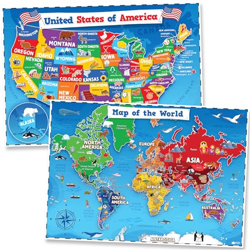
This 2-pack includes large, colorful world and USA maps designed for kids and classrooms. The posters feature bright colors and clear labeling to facilitate early geography learning. They are designed to be visually engaging without overwhelming detail, helping youngsters recognize continents, countries, U.S. states, and major capitals. The laminate and sturdy printing ensure longevity for daily use on classroom walls or bedroom decor.
Buying Guide: Key Considerations For Choosing Kid-Friendly Maps
- Interactivity vs. passive visuals: Interactive maps with spoken cues or questions engage auditory learners, while laminated posters offer durable, timeless reference material for visual learners.
- Durability and classroom suitability: Look for laminated surfaces, sturdy poster stock, and scratch-resistant finishes to withstand frequent handling by children.
- Age appropriateness: Younger children benefit from simple labels and vivid illustrations; older kids often appreciate more detail, including capitals, major cities, and flags.
- Content scope: Decide whether you want broad global coverage (world maps) or focused regional learning (USA maps) to align with curriculum goals.
- Versatility: Posters that can double as wall decor and learning aids encourage frequent use in study areas, classrooms, and communal spaces.
- Educational extras: Cards, games, or voice-guided features add depth by turning passive viewing into active recall and memory-building.
- Care and maintenance: Ensure easy-clean surfaces and non-toxic inks for safe, long-term use in homes with kids.
- Multisensory learning: Combining visual, auditory, and kinesthetic elements can improve retention and engagement across diverse learners.
- Recommendations and awards: Awards and educator endorsements can signal reliability and educational value for homeschooling or classroom adoption.
In choosing the right maps for kids, consider how the set will fit into daily routines—whether used for quick morning reviews, interactive family games, or classroom centers. The blends of interactive features, durable posters, and visually engaging designs can support a steady buildup of geographic literacy while keeping learning exciting and age-appropriate.