Exploring the world begins at home. The right map-focused tools can boost curiosity, memory, and spatial awareness for children aged 3 to 12. This guide presents a curated selection of kid-friendly maps and map-inspired puzzles designed to educate without overwhelming. From colorful wall posters to interactive talking maps and hands-on jigsaw sets, these options support early geography learning, classroom decor, and engaging family activities.
Summary of Selected Products
| Product | Format | Age Range | Key Benefit |
|---|---|---|---|
| World Map Poster & USA Map for Kids 2pc Set | Posters | 1-5 | Visual geography and country awareness |
| 2 Pack World & USA Map for Kids | Posters | 3-8 | Durable laminated wall posters for ages 6-8 |
| BEST LEARNING i-Poster My USA | Interactive Poster | 5-12 | Audio voices for states, capitals, facts |
| Imagimake Mapology USA & World Map Puzzle | Puzzle | 8-12 | Flags, capitals, and country differentiation |
| The Learning Journey Lift & Learn USA Map Puzzle | Puzzle | 3-6 | Raised pieces and tactile learning for younger kids |
World Map Poster & USA Map for Kids 2pc Set
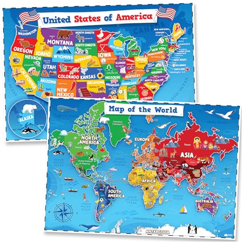
The 2-piece set from Momo & Nashi combines a World Map Poster with a United States Map Poster, designed to spark early curiosity about continents, countries, and state-level geography. Aimed at toddlers and young children, the vivid illustrations foster visual learning and memory retention in classroom decor, homeschool setups, and play spaces. The posters use bright colors and clear labeling to reduce distraction while encouraging exploration of geographic relationships.
Features highlight interactive layout, up-to-date details, and kid-friendly icons. The design emphasizes readability and clean presentation, enabling teachers and parents to guide discussions about geography, landmarks, and regional diversity. The posters are crafted to fit kid spaces, making it easy to display learning aids without overwhelming a wall or room.
2 Pack World & USA Map for Kids [Illustrated]

This Palace Learning set includes two laminated posters—World Map and USA Map—meant to withstand classroom use and daily handling. At 18″ x 29″, these posters provide ample space for labeling, tracing, and student annotations. The 3-millimeter lamination adds durability, helping posters resist wear in busy learning environments. Ideal for elementary classrooms or homeschool spaces, this pair supports a broad range of geography lessons, from continents and oceans to U.S. states and major cities.
Durability and readability are prioritized here, with clear, large typography and continent-level detail. The laminated finish aids cleaning and reuse over multiple years, making it a practical choice for ongoing geography curricula and wall decor that stays vibrant through frequent use.
BEST LEARNING i-Poster My USA

The i-Poster My USA from BEST LEARNING is an interactive wall or floor map designed to engage children ages 5-12. When a state is tapped, it speaks its name, capital, and over 500 facts. This auditory feature reinforces memory through multimodal learning, combining visual maps with spoken content for a robust geography experience. The product has earned multiple awards, signaling trusted educational value for both home and classroom use.
With the option to place the map on a wall or floor, it supports various learning styles, including quiz-style activities, independent study, and group reviews. The combination of durability, interactivity, and cross-situational utility makes it a versatile addition to geography curricula and family learning lounges alike.
Imagimake Mapology USA & World Map Puzzle

This Imagimake Mapology kit combines USA, World, and Europe maps into a single educational puzzle set. It features country shapes, capitals, flags, and stickers, fostering hands-on geography learning for kids aged 8-12. The puzzle pieces are designed to support spatial awareness, logical reasoning, and memory through interactive assembly. It’s a resource that blends cognitive challenges with geography knowledge in a single, engaging activity.
Beyond simple map recognition, the inclusion of flags and capital stickers adds a cross-curricular element—connecting geography with civics and world cultures. The three-map format provides a broader scope for classroom activities, family game nights, or holiday teaching moments that emphasize global awareness.
BEST LEARNING i-Poster My World
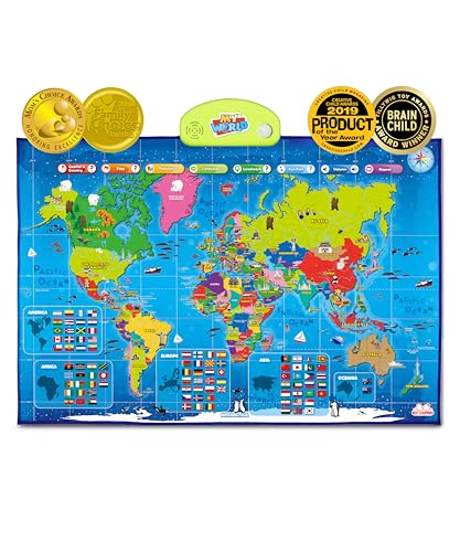
The i-Poster My World from BEST LEARNING mirrors the USA-focused model but on a global scale. This talking world map guides children through continents, countries, oceans, and landmarks with over 500 spoken facts. The award-winning design emphasizes culturally aware geography learning, making it suitable for classrooms and homes seeking a structured, interactive world map experience. It supports learners who benefit from auditory cues, repetition, and kinesthetic engagement during map exploration.
Imagimake Mapology World Map Puzzle

Imagimake’s World Map Puzzle with Flags and Capitals expands geography learning through a globally themed puzzle. With 75 country-shaped pieces and 65 world flags, this set helps kids grasp international borders, capitals, and national identities. The included Europe map adds depth for continent-focused lessons, making it a comprehensive resource for curious minds exploring world geography. The product emphasizes accessible, step-by-step assembly and is designed for kids aged 5-12, offering an engaging, collaborative learning activity.
The Learning Journey Lift & Learn USA Map Puzzle

The Lift & Learn USA Map Puzzle from The Learning Journey targets younger learners with 40 pieces representing the fifty states. The raised textures on each piece support tactile recognition and fine motor development as children place states in their correct spots. The compact dimensions and sturdy build make it suitable for small hands and classroom centers. This puzzle emphasizes independent learning, visual matching, and problem-solving as children build a completed map of the United States.
Buying Guide: Choosing The Right Map Tools For Kids
- Age and learning style: Posters work well for visual learners and group lessons, while puzzles support hands-on and kinesthetic learners. Interactive maps cue auditory or touch-based engagement, ideal for students who benefit from multiple senses.
- Durability and material: Laminated posters endure classroom wear; foam or sturdy cardboard puzzle pieces withstand frequent handling. Consider washable finishes for classroom use and long-term value.
- Format flexibility: Wall posters save space and facilitate quick geography lessons, whereas floor or interactive maps offer movement-based activities, quizzes, and standalone play.
- Content depth: For younger children, focus on continents, basic country locations, and major landmarks. For older kids, include capitals, state names, and regional relationships to deepen knowledge.
- Interactivity level: Audio-enabled maps provide reinforcement through listening, while visual-only maps rely on labeling and color-coding. A mix of formats can accommodate different days or topics.
- Portability and setup: Removable posters are easy to rotate between rooms. Puzzles can be used in small-group centers or at a dedicated geography station, enabling collaborative learning.
- Assessment and progression: Choose tools that offer incremental challenges—starting with global geography and moving toward country-specific details and state-level facts as learners grow.
- Decor aesthetics: Bright colors, clear labels, and organized layouts help reduce visual clutter and support a focused learning environment.
These map-focused tools provide a spectrum of options to fit classrooms, homeschooling setups, and family learning environments. By pairing posters with interactive and hands-on puzzles, educators and parents can reinforce geography concepts through multiple modalities, helping children build a lasting understanding of our world.